Home / Ōshū Kaidō / Suzumenomiyajuku
Suzumenomiyajuku 雀宮宿

| Ōshū Kaidō (奥州街道) | Station 16 of 27 · Nihonbashi (Edo) → Shirakawa |
|---|---|
| Nikkō Kaidō (日光街道) | Station 16 of 21 · Nihonbashi (Edo) → Nikkō |
| Present-day location | Utsunomiya, Tochigi, Japan |
| Prefecture | Tochigi (Kanto region) |
| Next station | 宇都宮宿 |
| Coordinates | 36.4938° N, 139.8729° E |
It's the 16th boarding station in Kadeshau. The present TochkakiiUnonomiya temple.
Overview
Suzumenomiya-juku was a post town in Kawachi District, Shimotsuke Province, during the Edo period. According to the Nikkō Dōchū Ryakki, the station was originally called Dai-Yokota Village, after the settlement on the upland part of Shimo-Yokota Village, and in the days of the old Ōshū road its centre lay east of the later station; but when the Nikkō Kaidō was laid out during the Genna years (1615–1624), houses gathered along the road and formed a station, which was renamed Suzumenomiya Village after the nearby Suzumenomiya Shrine and was later made an official post station by the Edo shogunate. At first it was territory of Utsunomiya Domain, but the shogunate, which valued the station, made it a directly administered territory from 1744 (Enkyō 1), governed by a deputy (daikan).
According to the Nikkō Dōchū Shukuson Taigaichō of around 1843 (Tenpō 14), Suzumenomiya-juku had one honjin, one waki-honjin and 38 hatago inns, with 72 houses and a population of 268 within the station. It was a pure street village stretched along a single road, with neither side streets (yokochō) nor back streets. The station extended about 5 chō 20 ken (roughly 581 metres) from north to south, divided from the north into Kamimachi, Nakamachi and Shimomachi; in present-day place names, Suzumenomiya 1–2 chōme correspond to Kamimachi, 3–4 chōme to Nakamachi, and 5–6 chōme to Shimomachi.
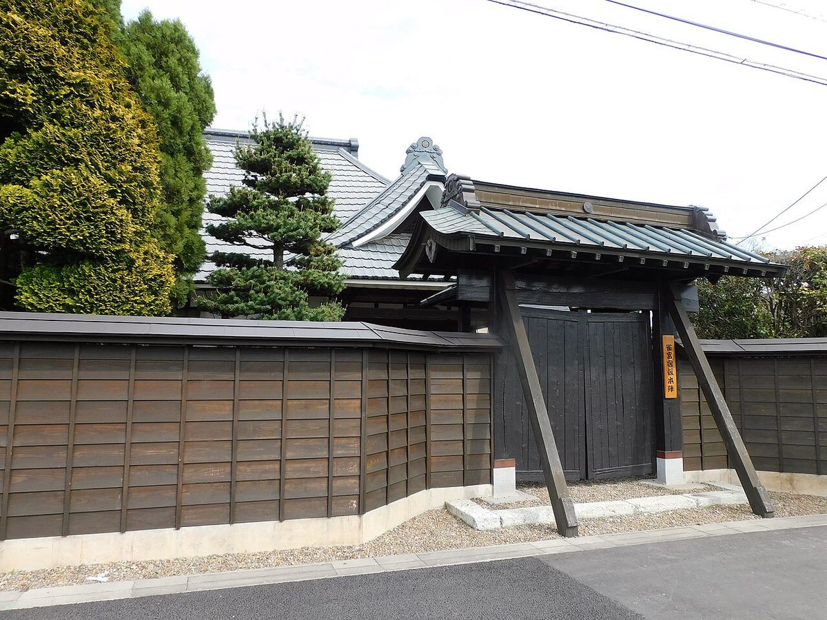
National Route 4, the old Nikkō Kaidō, still runs through Suzumenomiya today, and the JR Utsunomiya Line (Tōhoku Main Line) passes nearby, with Suzumenomiya Station. Traces of the post town could still be seen in many places until around 1955 (Shōwa 30), but the area changed greatly over the following half-century. The honjin, which stood in Nakamachi (present-day Suzumenomiya 4-chōme), was kept for generations by the Ogura family, former retainers of the Utsunomiya clan, and its gate structure survived into the 1990s; it was demolished when the descendants moved away, and only a monument remains on the site. About 100 metres further north stands the house of the Ashiya family (Suzumenomiya 3-chōme), which served as a temporary honjin; its black gate, board fence and raised-floor room (jōdan-no-ma) still evoke the old days.
Equipment
This is honjin. The temple hall, the Nintendo, the Light Temple, the Golden Court, the Grand Hall, the Synonym, the Synonyms, the Console, the Cyclopædia, the Kingship, the Japan Department, the Emperor of Japan. The connection road, the sun road, the convex road, the citadel road.
Traffic
The next room. I'm in the sun, I'm in the deep. (Sun-tro-East)
Text adapted from the Japanese Wikipedia article 雀宮宿, whose full text was translated into English for this guide by its contributors, licensed CC BY-SA 4.0. Station facts cross-checked with the road station lists (Japanese Wikipedia, CC BY-SA 4.0) and Wikidata (CC0).